Friday, August 2, 2013

So Long and Thanks for All the Ticks

By Juliane Menezes and Sylvia Kinosian

Bianca, we'll miss you!
The time has come for the LANDS "CR00" to say goodbye - LANDS program 2013 is now 100% complete!  The 9th week was all about finishing general tasks, editing and wrapping up all the reports, organizing gear, and making Bianca shine!  The STP reports were getting finished up with maps, photos and final formatting. On Wednesday evening, we threw a barbecue parteeeyyy at Red Rocks Park.  Swimming, kayaking, playing volleyball and frisbee, and eating burgers/ veggie burgers was what we needed to continue the rest of our last busy week. 


We spent Thursday preparing for and giving our final presentation. We created a powerpoint did a practice run through of the presentation early in the afternoon to get ready for the final evening. We were a little nervous to present to an audience, but our practice payed off and we rocked it! Our audience really seemed to enjoy the show - and so did we! Reflecting on our hard work over the summer was very rewarding. We all have a lot to be proud of! 

Friday was all about finalizing our experience, giving thanks and saying goodbyes for a few of us. Jacob is going back to the famous Central Michigan University; Liz back to NY; Julie to Madison, Wisconson and Maria is going back to Brazil. Have a nice trip Maria! We hope that LANDS internship had closed your year in U.S with a “golden key.” Now, LANDS, you deserve some vacation! Enjoy the rest of the summer before classes start again. Ride your bikes, go swimming, get some rest, and HAVE FUN! 

"Pease" Out!

Gomo Town Forest Johnson, VT


Kristian Moore
Michael Storace
This week Michael Storace and Kristian Moore hit the road early for Johnson Vermont. Meeting our small team project (STP) sponsor, Lois Frey and the Johnson Conservation Commission at the Municipal building in the village of Johnson. After getting a quick rundown of Gomo Town Forest's natural and cultural history we followed Eric Nuse, the previous county game warden and walking encyclopedia, up the treacherous Codding Hollow Road and into Gomo Town Forest.
Gomo Town Forest is a 141 acre parcel of land located in the northwestern corner of Johnson, VT. It is bordered by the north and south by Vermont State land and borders the town of Waterville to the west.  Bisecting Gomo Town Forest is Codding Hollow Road, a class four road no longer maintained by the town or passable by street vehicles. ATV traffic is the only traffic that uses this road, and unfortunately has begun to radiate off the road and into surrounding fields and forest. 
There is another trail that winds it's way through the southern section of the property, and a logging path that follows the eastern border north to the border of VT state land and Gomo Town Forest. 
Our main objective for this project was to map all trails and their condition, map the location of cultural artifacts, and connect the Gomo property to the Long Trail, all while finding the best way to increase the number of visitors to this unique piece of land and the beautiful ridge line trail to Laraway Mountain (above photo).
Old Doodlebug truck, the last vehicle to regularly make the trip up Codding Hollow Road and to the Gomo Farm.  


Kristian and Mike enjoying the view from Laraway Lookout. 
We followed old logging roads and bushwhacked our way to the Long Trail from Gomo Town Forest. At the Laraway lookout two of Kristian's friends from high school appeared. They were on day 21 of their South - North through hike of the LT. After a nice unexpected visit we continued our hike to Codding Hollow Road and completed the 5 mile loop trail we proposed to the Johnson Conservation Commission.  


LaPlatte River Marsh: Invasives Nightmare!

By Juliane Menezes and Sylvia Kinosian

Our favorite natural area


Julie and Sylvia went to Shelburne Bay, only a few minutes south of Burlington, to start working in the LaPlatte River Marsh Natural Area. Mollie Klepack, who works with The Nature Conservancy (TNC), showed us around the area and told us about a few projects that have previously been done in the area to remove the invasives. In a few weeks, a large scale invasvies removal effort will begin, implemented by Restart Forestry. This private consulting company has been hired by TNC and funded by a special grant to do some much needed removal of the invasive infestation. Our project was unique among the other STPs in that TNC asked to create our own monitoring protocol for invasive species monitoring. We decided to use a random plot sampling method to estimate the percent cover of the invasives present; the centers of each one of our 20 plots were marked with GPS waypoints as well as rebar stakes so finding them again will be very easy to find during future monitoring efforts.

Simplicity and ease of use was one of our top priories when creating our monitoring protocol because it will be used by TNC interns and volunteers to collect data after the removal effort; future data will be compared to the baseline data that we collected and used to measure the effectiveness of the chemical and mechanical procedures used on the invasives.
A most beautiful of maps. Oh ArcGIS, how we will miss you.
Over the 8 weeks working with LANDS, we have never seen a place dominated by invasive species like this section of the LaPlatte! We spent most of our time in the field bushwhacking a dense population of honeysuckles and dogwoods. We were basically swimming in a sea of honeysuckle! Hopefully the removal effort be a a success and someday soon the LaPlatte Rive Marsh will be a lovely, invasive free natural area for all to enjoy.

Honeysuckle ocean
In addition to our field work, we had the company of Joshua Brown: writer, photographer, and professor at UVM. He decided to include us, LANDS, in his article for the UVM website. Now we can say that we are Forestry superstars! 
"Hmm, indeed, this Lonicera sp. had got to go" - Sylvia and Julie, Stars of Forestry
Photo Credit: Joshua Brown

Wednesday, July 31, 2013

Wu Ledges

By: Rachel Markey


This week, Sam, Maria, and Rachel all headed down to Waitsfield to check out the elusive property known as Wu Ledges. We were ready to map out a network of trails, but did not realize what exactly we were dealing with until our sponsor, Mark, described them as a "spaghetti mess."

We felt like this. 

But afterall, things were not so bad. We spent 2 full days in the field, and mapped out almost 6 miles of winding mountain bike trails. We took note of their conditions and any special features they had to offer. Once we were on a roll with finding, tracking, and mapping the trails, we began to enjoy ourselves on the property.  

One of the many eastern newts we found!


Final trail map with all points of interest. Phew!


Pease, please!

This week, Jacob, Liz, and Martine headed out to Charlotte to explore the Pease Mountain natural area. Pease Mountain, the twin of Mt. Philo, has a small trail system that we set out to map. To our great enjoyment, we discovered several small trails that led to lovely views of the surrounding landscape. We offered many management recommendations to help deal with the excessive muddiness, such as rerouting trails and installation of boardwalks. From our conversations with local Pease enthusiasts, we understand the great value of this low-impact recreational area to the community, and are really grateful for the opportunity to help contribute to the longevity of this very cool place.


Tuesday, July 30, 2013

Week 8: July 22 to 26

By Juliane Menezes and Sylvia Kinosian

This week we started our last project as a whole group! The Conservation Commission of the Williston, Vermont hired us to make ecological assessments in three different locations that may be placed under conservation easements. The three areas had some interesting names: Bur Oak Knoll (Bur Oaaaaaks!), Glacial Spillway (Ice Age) and Johnson Falls.


Kristian chillin’ on the tree hunting stand.


One person of each group was responsible to find historical data about their respective area. Sam, Liz and Rachel searched in hundreds of folders and files in the Town Clerk Office for valuable information about historical land use, property landowners, and easements. The rest of the crew were responsible for collecting info about natural communities, wildlife, natural and human disturbances, topography and hydrology. We also looked for historical maps and aerial photographs in UVM Memorial Library. It was kind of interesting to notice the changes of the landscape in time. In other words, basically everything that we have been doing on previous projects in this summer. We are masters at doing ecological assessments by now!


Glacial crew crossing this old bridge (One at a time!)  

We did the entire project, which includes the assessment of the properties and report writing, in only 3 days. Good job everybody! 

It's time to play What's That Small Nondescript Herbaceous Plant?!

Done with the Williston project, we started our Small Team Projects (STPs)! The projects chosen by our crew were: Gomo Town Forest (Kristian and Mike), Pease Mountain (Liz, Martine and Jacob), LaPlatte River Marsh (Julie and Sylvia), and WU Ledges (Sam, Maria, and Rachel).  We had to do these projects on our own, without the help of Emily or Laura; contacting the sponsors, planning, gathering all the maps and writing the reports are entirely our responsibility.  The results of our independent projects are still a surprise! Good Luck LANDS!

Martine enjoying the shade of a Quercus macrocarpa

Friday, July 19, 2013

Week 7: Stuck in the suburbs

Map Partying (planning).
On Monday afternoon, we emerged from Bianca onto the steaming pavement of Essex Junction's Five Corners intersection. Our mission for the week was to inventory each urban street tree in the public right-of-way in Essex Junction Village, noting down species, size, and condition. The lovely Elise Schadler of VT Urban and Community Forestry guided us in our work, providing software training, treats, and insight in the context of this project. 
Like many of our other projects, this inventory is intended to inform management practices for the urban forest. Data from this inventory may help monitor a disease outbreak, or prevent hazards and altercations. In addition, the project has a strong community aspect in that it intends to raise awareness of the importance of a healthy urban forest and expand public support. Town planners may use this data to establish tree dollar values, providing an economic lens to promote tree conservation.

Often overlooked as a crucial component of walkable, aesthetically pleasing neighborhoods, trees provide a wealth of benefits to communities. Urban trees provide shelter from the sun, serve as passive cooling devices for buildings, improve air quality, buffer storm runoff, regulate temperatures, provide wildlife habitat, mitigate noise pollution, and generally improve the appearance of a place. Elise told us that trees can even function in crime reduction. Their presence provides a resource for environmental education initiatives, community engagement, and fostering a strong sense of place. They’re hugely important for maintaining healthy and functioning communities that are easy on the eye.


Some forestry stars.
We spent three days in the field wrangling with a slightly maddening software system called Juno to record data and GPS coordinates. Partitioned into 4 separate groups, we trekked through the village landscape wearing bright vests and seeing mirages (it was a sweaty week). Upon reaching a new street to inventory, we measured and calculated the right-of-way distance from the curb, which would tell us which trees fell in the public realm and which did not. For each tree we happened upon, we recorded an assemblage of data including DBH (diameter at breast height), species, GPS location, overall condition, and whether it had defects and/or needed consulting. We also noted any properties that could possibly use a tree in their yard. At the close of each workday, Elise uploaded our data onto the Vermont Urban Community Forestry Tool and we entered all our notes into an Excel document.


Don't be scared.
We found the urban forest to be, for the most part, in good health, with minimal instances of consultation necessary. However, some bad news is that there are many trees in Essex Junction Village that are susceptible to invasive pests, a situation which should be closely monitored. Promoting a more diverse age structure and species assemblage will encourage the long-term sustainability of this urban forest.


Stopping traffic.


"I love this software." -Kristian


Downtime at the Essex Town Hall. Thanks for the cold water.


End-of-the-week-treats. Thanks, VT Urban and Community Forestry superstars!

Despite the oppressive heat, we had a fun week. Thanks so much to Nick for the pool party!

-the cr00

Friday, July 12, 2013

Week Six: July 8-12

By: Rachel Markey

Monday morning we all had an unexpected start to what we thought would be just another office day. Emily held back her plans from us and piled us into the van as it started to rain. You could say that we were all a little bit confused as to why we were going “out into the field” when not one of us was rain gear prepared. Once we pulled into the parking lot of Oakledge, it was safe to say a few of us could figure out where we were being taken that was sheltered and out of the rain.
Once we all took a seat inside the Oakledge TreeHouse, Emily read us a short story by Barbara Kingsolver. After reading, we all set down to complete a reflection on our time here at LANDS. By this time, we had just completed our 5th week, over halfway through the summer.


Back on campus, we began editing and revising the final versions of all 5 of our written reports. It took all day, and some of Tuesday to finish the revisions. After finishing, we had completed full reports for the East Woods Natural Area, the Pomainville Natural Area, the Roche property, and Concord Woods Natural Area. Now to start the next project....


Tuesday afternoon we headed out to Bolton to meet up with Kathryn Wrigley so she could introduce us to our new project. We would begin our work on the Smith parcel, a piece of land in Bolton which was purchased by the Green Mountain Club. The GMC then transferred the ownership to the State of Vermont Agency of Natural Resources so they could hold it in perpetuity for conservation. Currently, a section of the Long Trail is being rerouted through the property.


Our job was to complete natural community inventory and mapping for the property. This would help the GMC and VT ANR determine characteristics of the land. We set out into the field Tuesday afternoon, and despite having only about an hour and a half to check it out, managed to define two natural communities and get a pretty good sense of what we were dealing with.
Sam & Martine checking out soil, topography, and surficial and bedrock geology maps


And thanks to Mike, the WeatherWizard, we were able to stay dry and out of the rain during our field work.


When Wednesday rolled around we were all reading with all of gear to head out to Bolton for an entire field day. Three groups set out within the 177 acre property to assess and attempt to mark the transitions between the natural communities of the parcel. Throughout our time exploring the property, we found many cool features of the land. Such as...


Thursday we spent the whole day  in the office writing up our report for the Smith property. We compared our notes, once again, to Wetland, Woodland, Wildland and attempted to piece out the natural communities we encountered within the property.


Friday morning we all arrived ready for some weeding at the Forest Service again. Thankfully, it was a beautiful day and none of us really minded being out in the sun. It only took us about an hour and a half to complete the weeding! We attempted to start digging out an old experimental plot tank, but it was filled with rainwater and mud, so we headed back towards campus.
Back on campus, we met up with Elise Schadler, who works for RSENR and VT ANR. She wanted to find out how much we all knew about urban forestry and street trees. Split into groups of two, we set out in downtown Burlington to see how many street trees we could find, sample, and identify. Together, we came up with over 50 species of trees, and were rewarded with Sour Patch Kids, Swedish Fish, and a crew frisbee.


After that some of us headed back to the computer lab to edit and revise the final draft of our Smith Property report. The rest of us got started on our weekly chores, and well, that’s where we're at now....

Friday, July 5, 2013

Week Five: Concord Woods Project

July 1st-4th

by Maria Clara Starling

What started out to be LANDS' shortest week turned into one of the longest ones. For our fifth week, we were awarded with the privilege to explore Concord Woods Natural Area. This 100-acre property is a piece of land in North Concord, VT. Donated to the UVM Natural Areas in 1944, its uniqueness relies on the fact that it is a well preserved piece of Northern Hardwood Forest (with some variations). On the other hand, its surrounding region has been heavily logged (completely clear cut). Working in Concord Woods meant a break from our now well-known invasives (not a single Buckthorn was traced). Meanwhile, it taught us how boundary marking and navigating in steep (very steep) elevation, looking for 30 year old blazes, and (of course) below heavily pouring rain, can be tricky. 

Monday 
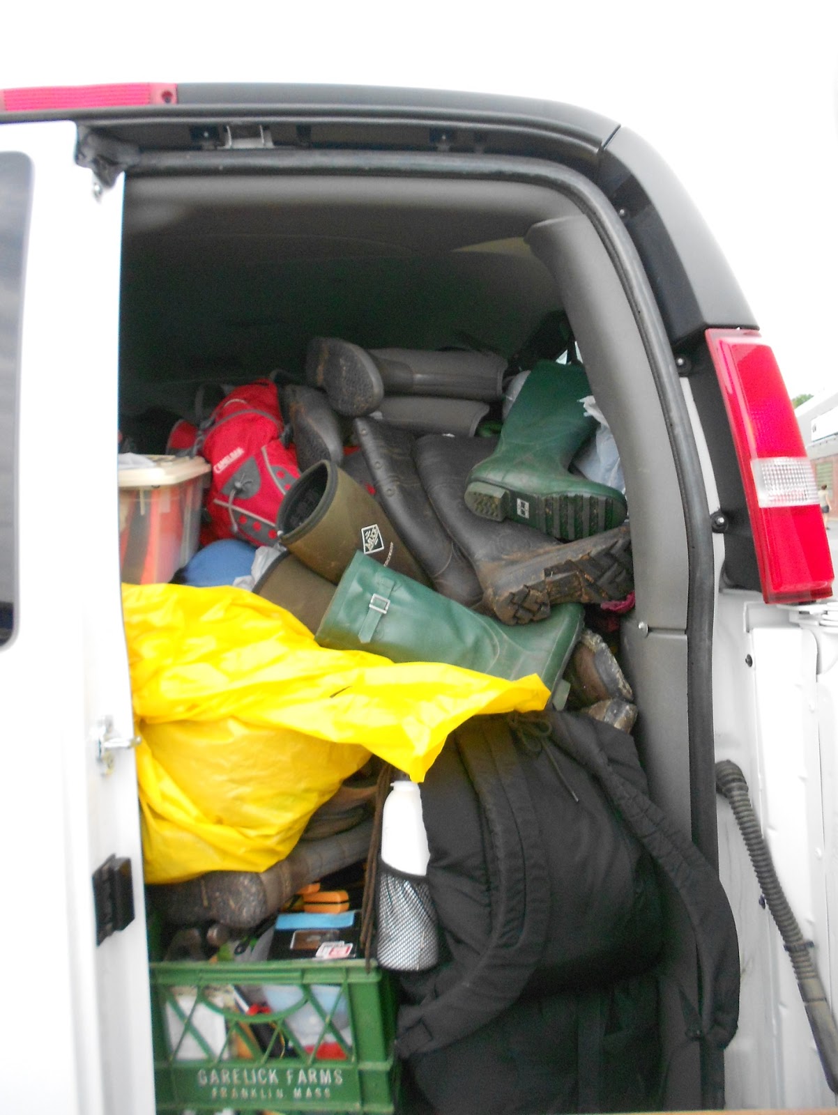
started earlier than usual with van packing at 8 am. Yes, Bianca was packed, once again, but she manages to be such a great team member that everything fit well (not!). Laura was the smooth driver this time and at around 11 am we met Becky and Rick Paradis who were going to tell us about the property and nominate tasks (thanks for trusting us again!). After one hour chatting about Concord Woods’ natural history, looking at maps and discussing project details we had a game plan and started the hike up to the property. One of our tasks was installing four corner posts on their unknown proper location. Therefore, we made a quick stop in the middle to grab some digging tools and four shiny red pressured treated hand-marked corner posts that were carried up with us (credits to Becky). Posts were marked according to the 1700s survey when US territory was 
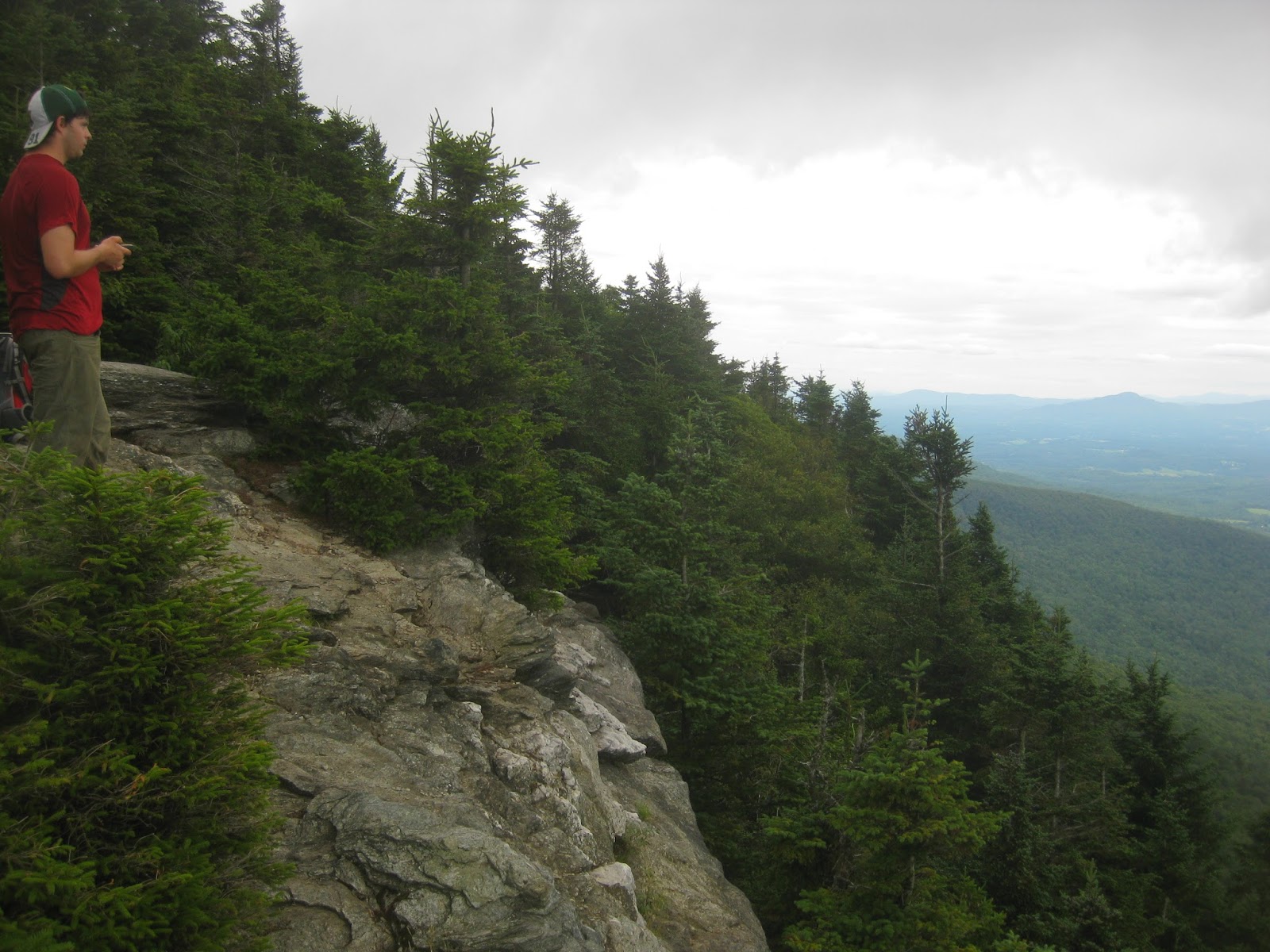
split on lots and ranges delineating properties. After following blue flags up the hill we got to our first boundary corner where we found a short decomposing orange post that came from a mysterious source. Then, we split into 2 groups that would explore eastern and southern boundaries looking for old blazes and equally mysterious orange posts each. Both teams left to accomplish their tasks while Emily and Laura were addressed with the digging mission. One of the teams was successful on finding some old blazes and the post after a precipitous climb up within a dense well conserved forest to the eastern corner. The property boundary was also somewhat clear by tree age on both sides.  The other group struggled a bit to find old blazes and followed the mapped bearing up to an interrupted barbwire fence.  Back to the first corner (where a brand new bright red post already laid on the place of the second one) and down the mountain we went to get groceries and set up camp. Tents up, fire lit, dinner cooked, s’mores devoured. It was time to go to bed under continuous water drop sounds that persisted heavily through the entire night. 

    “Caution! Items may fall while opening the door” 


                                                 Carrying posts and tools up the mountain


                                             Old corner post and shiny and bright new ones!


Tuesday morning’s alarm tone was a frenetic oven bird that seemed to be pumped up by all the rain that kept falling.  Unfortunately, we accidentally had food and trash left out during the night which attracted messy rodent company.  As we gathered in the lean-to after breakfast to “bring our minds together”, wet-tent night stories started popping up. Some of us had had their sleeping bags totally soaked and a long night experience.  The talk was necessary to bring us back to a positive mind state. Duty still called us and we were presented with a streamlined plan for the day: a field naturalist relay with a blazing and digging tools exchange.  Four stages, three groups, three corners to be properly blazed in order to keep loggers out of our untouched forest, and countless special features to be registered. Rather challenging, as usual LANDS tasks, but there is something within us that always speaks louder and we just went for it! At some points during the climb we did wish Becky had made lighter corner posts, but we managed to get all of them up by the end of the day (awesome team work! Now we know that she made the posts this way just because she believed in us, maybe more than we did!)

Stage one down, rain picked up a little bit during stage two. Towards the end of stage two, weather conditions had slowed us down and so did difficulties to find old blazes and one of the old corner posts. All three groups ended up together at one corner and the decision was made to head back to the starting point and finish our mission on Wednesday. We went down with our eyes (and cameras) open for wildlife and unique features on the way. Leatherwood, huge yellow birches, moose scrapes, deer and moose scat, bear scratches on trees… a wonderfully rich forest!  As much as we aimed for concluding all of the four stages that day, we learned that when dealing with some circumstances we cannot control (such as the weather) it is okay to be below the (high) expectations we create for ourselves.  Back to camp, we made a clothes line and gathered all of the wet items that were essential to keep us warm. Emily and Laura took a bagful of sleeping bags, sweatshirts, pairs of paints and socks to the laundromat (thanks a lot!!).

                                                   Tuesday’s foggy morning tent perspective


  Stage one: check! Old blazes replaced by new ones!

                                        
                                 Wildlife signs: bear scratch and moose scrapes

        Clothes “line-to” 

Surprisingly, Wednesday started out as a dry morning. Camp down, breakfast eaten, lunch made and Bianca packed. It was time to do a little service for the camp site in order to pay for our stay. Trash picking, nail removing, spider web brushing, etc… Unfortunately, we came across another unexpected situation. While Julie was innocently cleaning one of the fire places a tree branch fell out of an old pine on her head. “Wrong place, wrong  time!” Luckily, small cut and no concussion. By the time all necessary bureaucracy regarding the incident was dealt with, we had a game plan and left to the field under the sun light! We met Becky and Silas (her dog and now 13th member of the LANDS crew!) at the usual parking place.  We gave Becky an update on what we had already accomplished and on our plans for the day. Our last search for two missing old posts started humid and sunny. However, half way up to the supposed corners, we were caught by a huge torrential storm. Refreshing as it could only have been, it followed us all the way to our “corners”. One of the groups seemed to have their eyes trained for old blazes and the barbwire fence mystery was finally solved. A corner post was found buried under a fallen tree (awesome eyes)! With three out of four, we headed back to base, completely soaked, but satisfied with the work we could accomplish against all of the odds.
With Bianca packed (and emitting a curious smell) we headed back to Burlington. Since it had already passed dinner time, we ordered pizza on the way and had delicious dinner on someone’s front yard (oops!). Timing couldn't have been better, we were out of the van and walking home just in time to watch 4th of July fireworks!

                                                            Service work for the camp


                                                            Buried corner post found!


                                                                     Torrential storm effect


Sunday, June 30, 2013

Week 4: June 24-28

by Jacob Guettler and Sam Smith

Monday
This week marked an entire month that our crew has been working together on various land stewardship projects!  It also marked another five days of rain, thunderstorms, and more rain.  We began the week in the office, finishing a report for NRCS about our last project at the Pomainville site in West Rutland.  After breaking for lunch in a brief period of sunshine, we gathered as a group in the Aiken lounge to discuss at length our next project.  This involved completing a very rapid ecological assessment of a privately owned piece of land in order to determine if the land holds ecological value.  This project was quite different from our previous assessments for several reasons.  First and foremost, we had to consider that only one day was allotted to determine ecological value!  How do you even define ecological value?  Fortunately we had an extensive discussion about our plan of action so that we were prepared Tuesday for a full day of field work. 


Tuesday
Arriving at the site early for our swift assessment of the property, we split up into four teams based on topographic features to comb the entire site.  Two groups walked each side of the river, one group inventoried the open fields, and one group tackled the forested section.   We all spent the day sweating profusely in the humid air, swatting at the endless number of mosquitoes and wishing we could swim in the river, which was full of sediment from recent heavy rains.  As each group surveyed their piece of the parcel, they took note of the plant and wildlife species present (or audible), unique topographic features, signs of human use, and soil properties.  Together, these observations were used to extrapolate what natural community types were present on the site.  Natural community classification was used to understand what is on the landscape and to make predictions about future habitat conditionsBy categorizing the landscape in terms of natural communities, we are able to understand species composition and infer distribution within a given area.


Each group had their own tale to tell about the natural and human features of the landscape that they observed. 

                                                     Julie "driving" an old tractor

Wed
After our quick work out in the field, it was back to the office to crank out another report of our findings.  We spent the day comparing notes, reading through the various natural community classifications in Wetland, Woodland, Wildland by Elizabeth Thompson and Eric Sorenson, creating maps of our findings, and playing jokes on each other in Google Docs (it’s the small things in life after all). 

Thursday
After quickly finishing our report for the property, we prepared ourselves for a day of service work. Our two tasks: 1. Weed the experimental plots at the US Forest Service Center, 2. Beautify the solarium at the UVM Aiken Center. We have weeded at the US Forest Service before and today wasn’t much different…except some of the weeds were GINORMOUS! It had been a couple weeks since we had last weeded and some of the plots clearly showed that. The trees were also growing and it was fascinating seeing the differences between plots in tree size and weed size.

Finally, we drove back to our home-base at the UVM Aiken Center. In order to give back to the Rubenstein School of Environmental Science and Natural Resources (Aiken Center) we helped beautify the solarium (a relaxing space filled with plants inside the entrance to the building). We divided up into two teams. One group helped fix the wetland display by moving the pools into proper places, so that the water would flow more easily. The second group repotted plants to be hung as a green wall at a later date. We were glad to have been of assistance helping to make the Aiken Center’s solarium an enjoyable place to sit back and relax.

                                  Martine and Rachel repotting plants for the Aiken solarium


                Maria hard at work designing and beautifying plans for a green wall in the solarium


                   Analyzing the water flow situation between the ponds in the wetland display

Friday
We met with Ralph Tursini, a forester, at the UVM ropes course to build a bridge. This was a service project for the UVM ropes course, thanking them for giving us a fun time, and bringing us closer together after our first week with each other. Ralph taught us some of the basic proper techniques necessary to fell a tree, in this case a hemlock snag. Ralph helped us out by using a chainsaw to cut down the snag and remove excess branches. We then worked together as a team to cut into the log, using an ax and mallet, in order to create a flat walking surface for the bridge. It was slow going at first, but then we picked up the pace thanks to Ralph and his chainsaw.

At this point, our plan from the previous day came into play. Ralph helped us cut down a tree with the perfect diameter, and smooth bark, for rolling logs. After tying several timber-hitch knots around out newly formed bridge, we began pulling the tree over the rolling logs. It was a wild journey to the stream where the bridge was to be placed. Rolling logs were moving all over the place and the bridge often seemed to have a mind of its own. By the time we were done we had moving a tree down to an art. With some fancy maneuvering and the placement of two base points in the muddy stream bank, our bridge was complete and ready for use. All in all, we made quick work of the tree and had a great time seeing our plan and bridge come to life.

                   Raplh Tursini removing branches from the hemlock tree used for our bridge at the                  UVM ropes course


                                                               Watching the tree fall!


 Definition of teamwork- pulling the log along the trail about 200 yards to its resting point in a small stream


                                                                                         The team on the finished product!